Well Log Data Management Software
Well log data is a key source for petrophysical analysis and machine learning models, however, it can be affected by a range of issues including...
2 min read

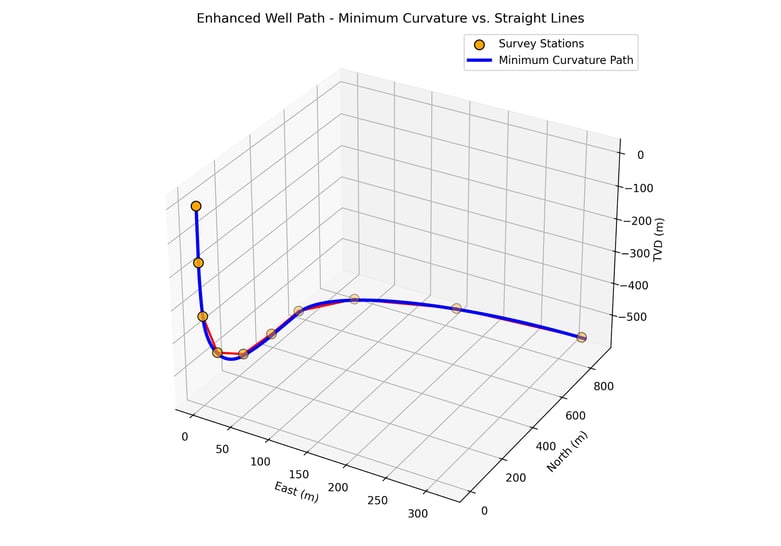
In wellbore surveying, precision matters. Yet despite advances in real-time data acquisition and trajectory modeling, we still encounter cases where linear interpolation is used to estimate borehole orientation between survey stations - especially when transforming Logging While Drilling (LWD) data into continuous measurements.
On the surface, this might seem like a quick and simple solution. But the reality is linear interpolation introduces avoidable errors that can compromise well placement, geosteering decisions, geological interpretation and, in some cases, even open the door to legal risk.
The use of Linear Interpolation to derive a continuous well path can lead to several inaccuracies.
Linear methods flatten curvature, especially in high-build or turn sections. This leads to artificially low DLS values, masking the actual stresses on the drill string and casing.
Even small errors in inclination or azimuth build up over depth. Linear interpolation can introduce systematic drift, placing your modeled wellbore meters away from its true position.
Many LWD image logs (e.g., gamma ray, resistivity, density) rely on accurate borehole orientation to unwrap and interpret geological features. Using linearly interpolated orientations can distort bedding dip, azimuthal features or fracture orientations.
Real-time decisions are only as good as the model behind them. Misrepresenting borehole position and orientation introduces uncertainty into landing, staying in-zone, or detecting structural changes.
Industry-standard survey calculations - including those recommended by SPE and ISCWSA - use minimum curvature or other high-fidelity models. Deviating from this can affect quality control and data compatibility.
Using inaccurate trajectory modeling techniques isn’t just a technical issue - it can carry serious legal and regulatory implications:
Poor trajectory estimation increases the risk of intra-field collisions, which can lead to liability for damage, production losses, and even trespassing into adjacent leases.
If trajectory errors result in missing a target zone, operators may face contractual disputes or cost recovery challenges under Joint Venture or Production Sharing Contract agreements.
Inaccurate surveys submitted to regulators - especially when not following accepted methods like minimum curvature - could result in penalties, permit rejection or compliance violations.
In many cases, root cause investigations after failures examine whether the correct industry-standard methods were used. Relying on simplified techniques like linear interpolation - especially when more accurate alternatives are readily available - can be seen as negligent.
Minimum curvature is the industry standard for good reason:
It's also well-documented, computationally efficient and compatible with anti-collision, geological and regulatory systems worldwide.
Using linear interpolation in directional surveying might seem like a shortcut - but it’s one that leads to avoidable errors, subsurface uncertainty and potential legal exposure. In an industry where millimeters matter, there’s simply no place for shortcuts in trajectory modeling.
At Geoactive, we believe borehole accuracy underpins everything from drilling efficiency to reservoir success. If you're reviewing your survey workflows or need help improving data quality from LWD or MWD tools, we’re here to help.
Oh, and if you want to join the dots together on a LWD survey when using Interactive Petrophysics (IP) please use the TVD module.

Well log data is a key source for petrophysical analysis and machine learning models, however, it can be affected by a range of issues including...

Nuclear Magnetic Resonance (NMR) logging has come a long way since its inception as a permeability tool, when researchers in the 1960s discovered the...