 Catriona Penman
The Geological Acrobat: How IC Flips, Twists, and Transfers Your Data with Ease
Imagine a tool that acts like a geologically aware Adobe Acrobat - flexible, fast, and format-friendly. That’s IC.
Exploration departments are continually being bombarded with two things: the social and political urgency to stop exploring for hydrocarbons; and the scientific and corporate awareness that exploration is still required. Exploration does not have to mean traditional oil and gas alone. Whether you are looking for additional potential in known, producing plays or looking for potential CO2 storage sites, our Interactive Correlations (IC) software will help you explore.
Exploration is driven by curiosity, and curiosity is the driving force of human nature. It leads us to travel further from the shore and continually ask “Why?” and “How?”. The subsurface is full of mysteries just waiting to be answered and as Explorationists, we are driven to find answers and explain what we discover like any good detective. Another name for detective may well be Explorer. We cross that horizon, we find out how to make things work, advance our technology and shoot for the stars. And we can apply that same curiosity to the exploration of mature basins to reveal new potential.
REGISTER HERE for the upcoming webinar: Conducting confident Cased Hole Analysis in IP!
The Paris Agreement, launched in 2015, is the legally binding international climate agreement aiming to limit the global temperature increase to 1.5°C pre-industrial levels. As the International community continue to take strides to achieve this in many complex ways, this article will focus on the continued need for energy and how that is met during this period of energy transition.
The word 'transition' itself ensures we understand there is a period of change and adjustment needed before we can come out the other end of this green energy revolution. The instantaneous switch from oil and gas to sustainable energy is not a technical, economical or even political reality. So while the volume and direction of demand for change increases, the reality is, we still need to explore for traditional sources, perhaps in more non-traditional plays, and that’s where explorationists have a part to play.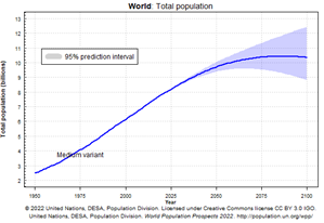
The United Nations (UN) forecast a global population increase from ~8 Billion today to 9.7 Billion in 2050 (see right).1 Meaning a continued growth in energy needs; more houses, transportation, food and fuel (to name a few). Exploration can, and is in many cases focused on finding potential storage sites for CO2, waste chemicals or other such “harmful” elements that impact the climate. However, the immediate requirements for energy must also include the need for new or revitalised prospects in proven oil and gas basins.
There are several forecasting methods for energy demand going towards 2050, one such is the IEA Stated Policies Scenario (Figure 1, below). Most international scenarios will not depict a complete removal of oil and gas, or even coal, by 2050.
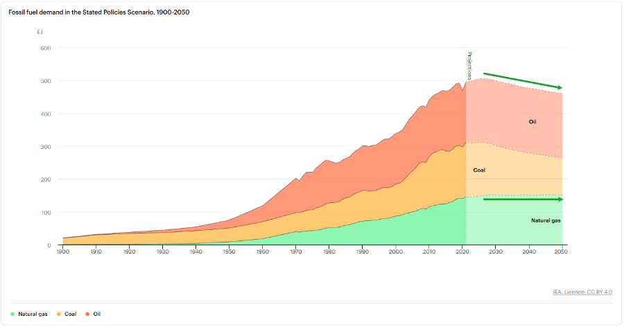
Figure 1: Forecast fuel demand. Modified with trend lines to show the forecasted decrease in oil demand and steady gas demand from now to 2050 from IEA, Fossil fuel demand in the Stated Policies Scenario, 1900-2050, IEA.
Mature Basins host proven hydrocarbon reserves in a working system, with effective, mature source rock with migration capabilities into quality reservoirs with effective traps and cap rocks. The specific parameters of viable prospects and productivity may vary from play to play and basin to basin, but as time progresses and the costs and value of extraction change, it is possible that previously overlooked, or deemed non-viable prospects may be worth a further look.
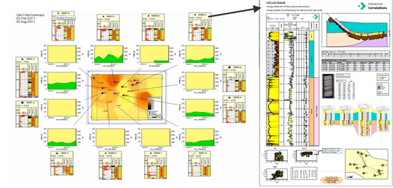
Figure 2: Using historical production data alongside borehole geological data and casing details help highlight anomalies and even explain these unexpected results. Adding more data and viewing it together will always result in further evidence to understand the subsurface asset being explored.
In some cases, using a “fresh pair of eyes” and new data integration and evaluation tools, it can be more valuable to evaluate mature basins for new potential. To determine the potential within a mature basin, it is vital to pull together all data from a multitude of sources, including public, subscribed, proprietary and historical into a structured database. IC enables this integration and even adds interactive visualisation of well data, along with a host of other tools that provide not only down-hole, but spatial relationships from well to well and zone to zone.

IC provides the home for all well related data that an exploration team can access and build upon. Using the toolkits that come as standard with IC, geoscientists can conduct their own data QC and evaluate the coverage and quality before even adding more. Exploration is conducted at a range of scales, from regional basin analysis to the prospect studies. Building a scalable solution within IC is key to efficient and effective working. Being able to go from a Basin-wide play fairway evaluation of the Lower Cretaceous, for example, to look at the minutia from one specific core photograph or thin section photograph is key to accessing the data available and making renewed assessments.
Being able to:
In order to achieve the global, governmental and corporate goals set to play a part in the reduction of greenhouse gas emissions, all companies and countries associated with energy resources are continuing their exploration efforts to advance what can be done, and where, to play their part.
Mature basin exploration means building a deeper understanding of the potential plays that could contribute to the energy demand in a way that will cause the lowest impact or even further the emissions reductions set out in legislation by identifying potential carbon storage sites
Identification of potential plays regardless of new or mature basins, require the same fundamental elements. Locating the “sweet spots” mean identifying the quality and quantity of each system element, source, reservoir and seal. The viability cut offs will vary from place to place and the economic position at the time of exploration but the technical elements are all the same. And this is where IC thrives.
REGISTER HERE for the upcoming webinar: Conducting confident Cased Hole Analysis in IP!
To revitalise mature basins, we must look beyond the traditional oil and gas potential and engage with alternative applications of these 'known' basins. We are not suggesting redesigning or replacing the knowledge gained, we are talking about new ways to use and think about the data we already have and include new data when available to achieve more. Fundamentally, we want to ask ourselves the following question: “What more can we learn from wells that are decades old and surrounded by dozens of other wells?". If that doesn’t lead to more questions then take a moment to read that line again.
With the continued growth of seismic acquisition and reprocessing improvements over the decades we now cannot imagine exploration without extensively utilising it. As a result, it can be easy to overlook the subtle power of well data. The simplicity of measured data and core recovered from boreholes combined can be seen as a lesser of the data available. This is not the case, and ignoring or downgrading the input from well data in preference of seismic or AI derived interpretations, can result in expensive and ineffective modelling and even missed opportunities.
Well data hosted in an effective database, like IC, provide a ground truth that can serve as the foundation for geophysical and petrophysical analysis, and should not be ignored when seismic interpretations do not match them. The primary focus on seismic interpretation to visualise and analyse an area may be a result of poorly structured datasets, or inadequate software being used and a wealth of data ignored.
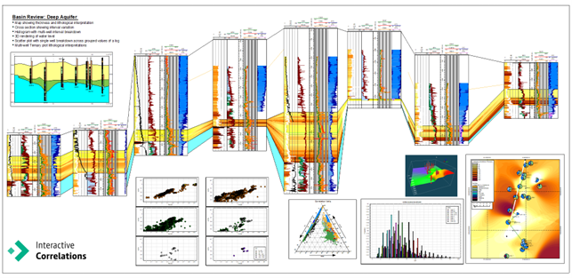
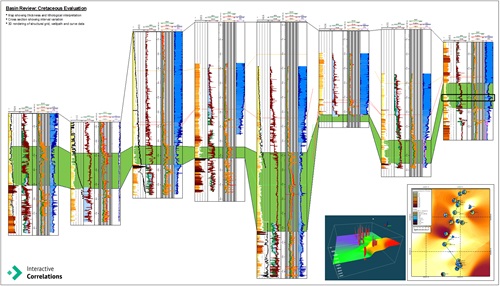
Figure 3: Example Basin review summary to evaluate the presence and quality of a deep aquifer within a mature basin showing the variation both laterally and vertically while digging into the additional detail from core analysis. Helping answer questions about mature basins for a new, revitalised purpose.
The best way to revitalise old data (and mature basins) requires integration of well data alongside seismic. Giving well data equal weight to seismic data leads to better understanding and higher confidence in your subsurface interpretation. This makes any future steps or investment opportunities more palatable, especially when applied to a new purpose like CO2 storage sites. Utilising IC to pull well data together in an easily comparable and accessible way can result in clearer understanding and potential prospects identified on a smaller scale that may still be viable.
We may anticipate that most plays have been found in mature basins, for example the North Sea, but as technology and experience grow, so does the potential to find something new with a fresh look.
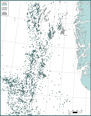
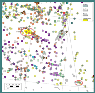
Figure 4: IC map of the north sea showing exploration well locations and discovery, and field outlines. |
The exciting position we find ourselves in during exploration projects is like an old mystery that is yet to be explained. We start with questions and need to find a place to start looking for the answers. Enter the Well data. Data that has been previously examined in isolation can be integrated in new ways using IC so we can now identify and potentially explain findings that were previously dismissed. This is where the conversation around assumptions applied to data in the past or to an area in the past may benefit from starting fresh.
An example of one such play from within the North Sea (a mature basin by anyone’s standards) is the Paleocene.
The oldest Paleocene field in the Norwegian Central Graben was discovered in turbidites in 1968. This, the Cod Field, later began production in 1977 that lasted over 20 years.
The UK side of the Central Graben hosts the Forties Field which was discovered in 1970 and began production 5 years later. Initial decline in production in the early 2000s coincided with the sale of the majority of interest. The Forties field is an international star of how field development
|
Figure 5: IC map zoomed in to the Paleocene Forties and Cod fields with well locations highlighting base zone formations in colour. |
progressed during the infancy of the North Sea hydrocarbon energy transition. By 1980 Forties Field development resulted in 58 platform wells. The additional data gathered provided a more clear understanding of the facies variations initially identified3. This is an example of where building in additional data during exploration and development can result in more refined interpretations and supporting a more confident understanding of the potential of an area.
Integration of log data, core data, pressure and production data can lead to practical and efficient correlation and mapping across a region. This is where IC can pull and display all that data together to aid answering questions about a play. Initially the Forties was expected to run dry by the early 1990s but continues to produce today and is expected to run for another 10 years4. This is a prime example of how more data (evidence) can be gathered and looked at afresh to answer questions and rejuvenate an aging asset.
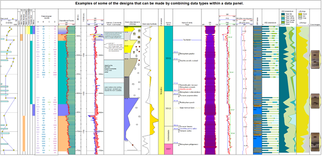
Figure 6: An array of data type displays for a single well exposing the truth of well data when looked at in conjunction with all data.
These reassessments and new forecasts would not be possible without combining new data, new thinking and new technology in these type of mature basins.
REGISTER HERE for the upcoming webinar: Conducting confident Cased Hole Analysis in IP!
It is absolutely possible to add more value and achieve further growth where exploration has already been successful. Especially now as we seriously determine the potential and role of depleted reservoirs for carbon storage. As the demand for ‘clean energy’ and ‘sustainable energy’ grow, so does the overarching need for energy.
IC is a pivotal solution that will combine and visualise data from all walks of life. Simple to complex, logs, picks and zones alongside images allow you to generate a visual explanation of your evidence. Being clear in your decisions based on visible data next to each other to explain the impact variations in interpretations can have is a time saver for any project. IC can thrive for you
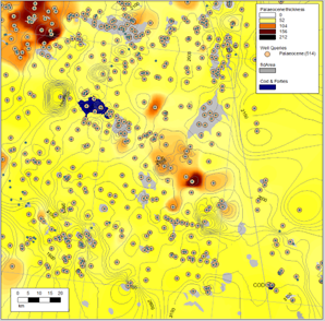 Figure 7: Example paleocene summary map showing reservoir thickness and structure with discoveries and field outlines in a mature basin. Figure 7: Example paleocene summary map showing reservoir thickness and structure with discoveries and field outlines in a mature basin. |
in your work as an explorationist, allowing you to jump from one scale to another in a single space. The ‘truth’, and your confidence in the interpretation, can be further established by running present day analogues incorporated with seismically derived surfaces in order to compare structural and stratigraphic interpretation with well data. Don’t just rely on assumptions made long ago when data and technology were different and not as clear or comparable against each other as they are now.
Mature basins may yet provide a second (or third) breath into the life of the prospectivity on your play. Being able to review and identify the potential in mature basins using an integrated approach to data management and visualization can lead to questions that further exploration, be that with new data acquisition or just further investigation, can answer. Gathering and working with all data is the evidence needed to ensure a confident and rationalised decision is made in these areas. No one should just write them off because they are mature.
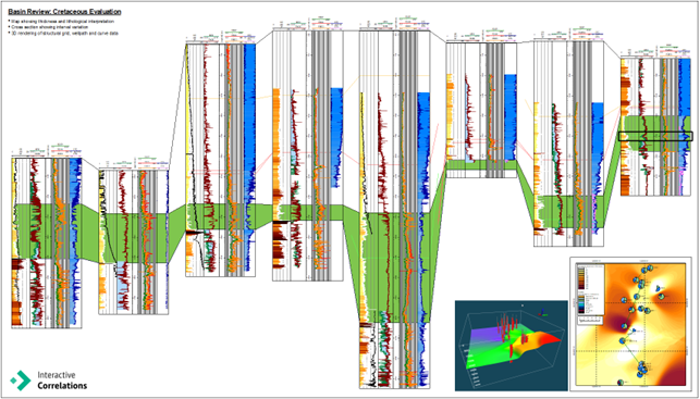
Figure 8: Example regional review of a specific play across a basin. Incorporating all available data can result in further investigation and answer those more complex requirements to achieve a successful prospect evaluation or even license round application.
Like any good mystery, where you are continually hypothesising “whodunnit”, exploration should likewise be abound with intrigue, unknowns and the gradual revelation of vital information. As evidence accumulates the deeper understanding you build, as does a clear and justified position to stand by. So, we say, let IC be your Hercule Poirot.
1 United Nations, Department of Economic and Social Affairs, Population Division (2022). World Population Prospects 2022: Data Sources. (UN DESA/POP/2022/DC/NO. 9).
2 IEA, Fossil fuel demand in the Stated Policies Scenario, 1900-2050, IEA, Paris https://www.iea.org/data-and-statistics/charts/fossil-fuel-demand-in-the-stated-policies-scenario-1900-2050, IEA. Licence: CC BY 4.0.
3 Carman, George & Young, Ray. (1981). Reservoir Geology of the Forties Oilfield.
4 Jane Whaley, (July 3, 2010). The First UK Giant Oil Field, GeoExpro.

Imagine a tool that acts like a geologically aware Adobe Acrobat - flexible, fast, and format-friendly. That’s IC.
The Challenge: Piecing Together the Petroleum Puzzle Understanding an entire petroleum system for a play is no small feat. It requires the...
Hey there, folks! Gather 'round for an exploration of the art of Geoactive software mentions. You see, when it comes to conversations with me,...