Real-Time Decision-Making Made Easy with WITSML
In the fast-paced world of oil and gas, timely decision-making is critical to operational success. Enter the WITSML Connector in IP – an innovative...
2 min read

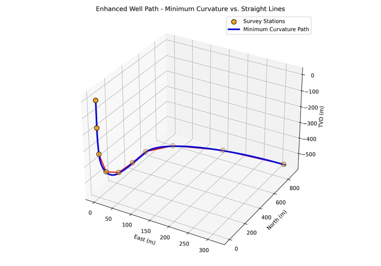
In wellbore surveying, precision matters. Yet despite advances in real-time data acquisition and trajectory modeling, we still encounter cases where linear interpolation is used to estimate borehole orientation between survey stations - especially when transforming Logging While Drilling (LWD) data into continuous measurements.
On the surface, this might seem like a quick and simple solution. But the reality is linear interpolation introduces avoidable errors that can compromise well placement, geosteering decisions, geological interpretation and, in some cases, even open the door to legal risk.
The use of Linear Interpolation to derive a continuous well path can lead to several inaccuracies. Namely:
Using inaccurate trajectory modeling techniques isn’t just a technical issue - it can carry serious legal and regulatory implications:
In many cases, root cause investigations after failures examine whether the correct industry-standard methods were used. Relying on simplified techniques like linear interpolation - especially when more accurate alternatives are readily available - can be seen as negligent.
Minimum curvature is the industry standard for good reason:
It's also well-documented, computationally efficient and compatible with anti-collision, geological and regulatory systems worldwide.
Using linear interpolation in directional surveying might seem like a shortcut - but it’s one that leads to avoidable errors, subsurface uncertainty and potential legal exposure. In an industry where millimeters matter, there’s simply no place for shortcuts in trajectory modeling.
At Geoactive, we believe borehole accuracy underpins everything from drilling efficiency to reservoir success. If you're reviewing your survey workflows or need help improving data quality from LWD or MWD tools, we’re here to help.
Oh, and if you want to join the dots together on a LWD survey when using Interactive Petrophysics (IP) please use the TVD module.

In the fast-paced world of oil and gas, timely decision-making is critical to operational success. Enter the WITSML Connector in IP – an innovative...

Using IP's cased hole log analysis modules, Exploration & Production operators and service companies can now oversee every stage of a well's...
For those working in other parts of the Energy industry, ‘Cased Hole Logging’ and ‘Cased Hole Data Analysis’ are probably terms you have heard in...